Binjareb-Peel Geopark Geodrive Trail

CLOSER TO NATURE

Explore the geological, natural and cultural wonders of the Peel Region along the Binjareb-Peel Geotrail, stretching from Mandurah to Lake Clifton, and out to Pinjarra and Waroona. This self-drive scenic trial highlights the unique geology, flora, fauna, and cultural heritage of Bindjareb Noongar Country.

Twelve sites along the trail provide detailed insights, with signage guiding you to explore the region's natural and cultural significance. From the remarkable thrombolites at Lake Clifton, the largest known occurrences in the southern hemisphere, to the majestic Murray River, each site tells a story of the region's deep connection to nature and history.

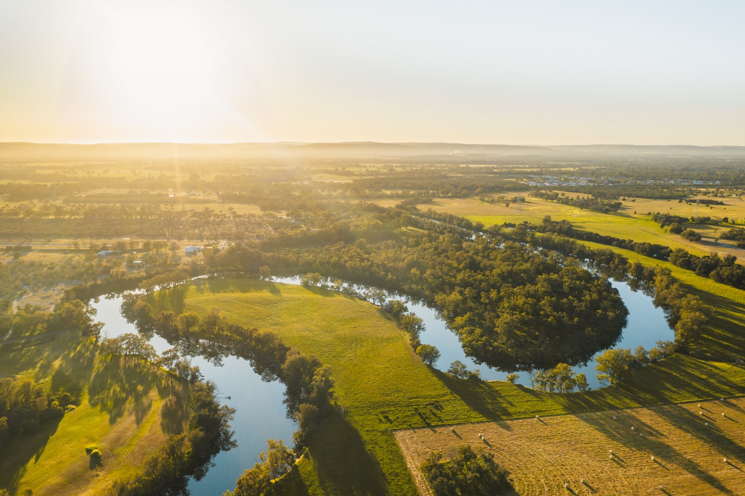
In Pinjarra, the Geotrail leads to the Murray River, a waterway lined with flooded gum trees and saltwater paperbarks. The river holds profound cultural importance, acting as the offspring of the Rainbow Serpent in dreamtime stories of creation. 

FOLLOW THE TRAIL

TRAIL HIGHLIGHTS

PINJARRA AND THE MURRAY RIVER

ImageExplore Pinjarra and the Murray Region in Western Australia

Start your exploration of the Binjareb-Peel Geotrail in Pinjarra, where the Murray River winds through riparian vegetation. See flooded gum trees (Eucalyptus rudis), she-oaks (Casuarina obesa), and saltwater paperbarks (Melaleuca cuticularis).

The Pinjarra geosite, located near the Edenvale Heritage Precinct, is an ideal opportunity to immerse yourself in Pinjarra’s rich heritage. Enjoy breakfast or lunch at the Heritage Tea Rooms before diving into the region’s geological, natural, and cultural elements.

As the Murray River flows through the vegetated slopes of the Darling Range to Pinjarra, it carries sediments from the Yilgarn and Darling Scarp, deposited over a long period of time. Here, on the riverbanks, four distinct periods of sediment deposition are visible—Coolup, Wellesley, Boyanup, and Blythewood (Seddon, 2004)—each revealing the region's ancient geological history.

Follow the QR code and discover more about the cultural significance of the waterways, geology, and biotic setting. The river ecosystem is home to a diverse range of wildlife, with up to 70 species observed throughout the area.

THROMBOLITES AT YALGORUP NATIONAL PARK

The Thrombolite Reef at Lake Clifton is a geological wonder and one of the largest known living reef of microbialites in the Southern Hemisphere. It reflects what the earliest lifeforms on Earth would have looked like.

The Lake Clifton thrombolites are approximately 2,000 years old. You can see the thrombolites from a boardwalk that extends over the lake, with the best viewing period from January to May when water levels are low, revealing the formations in their full grandeur. During the winter months, rising water levels submerge the thrombolites, offering a different perspective on these ancient structures.

For the Noongar people, the thrombolites hold deep cultural significance. In Dreamtime creation stories, they represent the eggs laid by the Rainbow Serpent, Woggaal Maadjit, at Noorook—the serpent’s nest.

Image

ISLAND POINT RESERVE

Image

Nestled between the Indian Ocean and the Peel Inlet, Island Point Reserve spans approximately 65 hectares and boasts a rich diversity of flora and fauna. The reserve is home to native wildlife, including western grey kangaroos, bush birds, waterbirds, and rare birds of prey.

Island Point Reserve also holds historical significance as a crossing route used by Aboriginal people and early European settlers for moving livestock across to the eastern side of the Peel-Harvey Estuary.

From the reserve, you can gaze eastward toward Herron Point, a popular campground offering scenic views across the RAMSAR-listed Peel-Harvey Estuary. The campground, near Pinjarra, provides a perfect base for exploring this ecologically and culturally significant region.

MANDURAH CHANNEL ENTRANCE

At the Mandurah Channel Entrance, the expansive Peel-Harvey Estuary converges with the vast Indian Ocean. Spanning 134 square kilometers—twice the size of Sydney’s Darling Harbour—the Peel-Harvey Estuary is a shallow body of water, reaching depths of only 2 meters at its deepest point in the central basin.

The estuary is home to a population of approximately 90 Indo-Pacific bottlenose dolphins, and over 70 species of fish have been identified in its waters. Local marine life, such as fish and stingrays, thrives in this ecosystem shaped by thousands of years of sediment deposits. To manage the buildup, annual sand dredging is conducted to maintain the health of the estuary.

Take in breathtaking scenes from the viewing platform, where the estuary and the ocean meet. This iconic site offers a glimpse into the dynamic forces that have shaped this unique environment.

Image

PINJARRA AND THE MURRAY RIVER

Image

Start your exploration of the Binjareb-Peel Geotrail in Pinjarra, where the Murray River winds through riparian vegetation. See flooded gum trees (Eucalyptus rudis), she-oaks (Casuarina obesa), and saltwater paperbarks (Melaleuca cuticularis).

The Pinjarra geosite, located near the Edenvale Heritage Precinct, is an ideal opportunity to immerse yourself in Pinjarra’s rich heritage. Enjoy breakfast or lunch at the Heritage Tea Rooms before diving into the region’s geological, natural, and cultural elements.

As the Murray River flows through the vegetated slopes of the Darling Range to Pinjarra, it carries sediments from the Yilgarn and Darling Scarp, deposited over a long period of time. Here, on the riverbanks, four distinct periods of sediment deposition are visible—Coolup, Wellesley, Boyanup, and Blythewood (Seddon, 2004)—each revealing the region's ancient geological history.

Follow the QR code and discover more about the cultural significance of the waterways, geology, and biotic setting. The river ecosystem is home to a diverse range of wildlife, with up to 70 species observed throughout the area.

THROMBOLITES AT YALGORUP NATIONAL PARK

Image

The Thrombolite Reef at Lake Clifton is a geological wonder and one of the largest known living reef of microbialites in the Southern Hemisphere. It reflects what the earliest lifeforms on Earth would have looked like.

The Lake Clifton thrombolites are approximately 2,000 years old. You can see the thrombolites from a boardwalk that extends over the lake, with the best viewing period from January to May when water levels are low, revealing the formations in their full grandeur. During the winter months, rising water levels submerge the thrombolites, offering a different perspective on these ancient structures.

For the Noongar people, the thrombolites hold deep cultural significance. In Dreamtime creation stories, they represent the eggs laid by the Rainbow Serpent, Woggaal Maadjit, at Noorook—the serpent’s nest.

ISLAND POINT RESERVE

Image

Nestled between the Indian Ocean and the Peel Inlet, Island Point Reserve spans approximately 65 hectares and boasts a rich diversity of flora and fauna. The reserve is home to native wildlife, including western grey kangaroos, bush birds, waterbirds, and rare birds of prey.

Island Point Reserve also holds historical significance as a crossing route used by Aboriginal people and early European settlers for moving livestock across to the eastern side of the Peel-Harvey Estuary.

From the reserve, you can gaze eastward toward Herron Point, a popular campground offering scenic views across the RAMSAR-listed Peel-Harvey Estuary. The campground, near Pinjarra, provides a perfect base for exploring this ecologically and culturally significant region.

MANDURAH CHANNEL ENTRANCE

Image

At the Mandurah Channel Entrance, the expansive Peel-Harvey Estuary converges with the vast Indian Ocean. Spanning 134 square kilometers—twice the size of Sydney’s Darling Harbour—the Peel-Harvey Estuary is a shallow body of water, reaching depths of only 2 meters at its deepest point in the central basin.

The estuary is home to a population of approximately 90 Indo-Pacific bottlenose dolphins, and over 70 species of fish have been identified in its waters. Local marine life, such as fish and stingrays, thrives in this ecosystem shaped by thousands of years of sediment deposits. To manage the buildup, annual sand dredging is conducted to maintain the health of the estuary.

Take in breathtaking scenes from the viewing platform, where the estuary and the ocean meet. This iconic site offers a glimpse into the dynamic forces that have shaped this unique environment.

CONTINUE THE QUEST

Embark on the full adventure by visiting all twelve stops along the Binjareb-Peel Geotrail Drive. This self-guided trail offers the flexibility to explore at your own pace, whether you choose to complete it in a single day or take a few days to immerse yourself in the regions and townsites along the way. Each stop reveals new layers of geological, natural, and cultural significance, making it a perfect journey for curious travelers.
FOLLOW THE TRAIL
 

TASTY TREATS AWAIT IN DWELLINGUP

Lorem ipsum dolor sit amet, consectetur adipiscing elit, sed do eiusmod tempor incididunt ut labore et dolore magna aliqua. Ut enim ad minim veniam, quis nostrud exercitation ullamco laboris nisi ut aliquip ex ea commodo consequat. Duis aute irure dolor in reprehenderit in voluptate velit esse cillum dolore eu fugiat nulla pariatur. Excepteur sint occaecat cupidatat non proident, sunt in culpa qui officia deserunt mollit anim id est laborum.